MAP CONTROLS: Use slider or mousewheel to zoom, and hold down left mouse button
to drag.
KEY: Location markers are coloured from Green meaning exact to Red meaning
gone or unknown (details here)
|
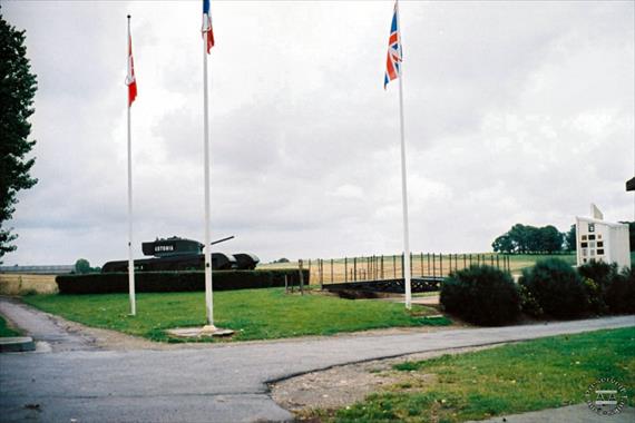
North of Le Havre there is a monument consisting of a Churchill tank, British and Canadian flags, a bridge and a display of unit insignia to commemorate Operation Astonia. This objective of this operation was the capture of the German-held port of Le Havre. A noticeboard on the memorial reads as follows:
| ASTONIA OPERATION. |
|---|
At the beginning of September 1944 Allied forces reached Belgium’s boundaries. The Fortress of Le Havre called “Festung” by the Germans was the most important port on the English Channel for supplying fuel, munitions and food. The Germans defended the “Atlantic Wall” with batteries, guns, strongpoints, minefields and an anti-tank ditch from the cliffs (at the west part of Octeville-sur-Mer) to Montivilliers where the valley was flooded by the river ‘La Lézarde’. ‘Astonia’ began 10 September 1944 under OC General Crocker of 1st British Corps, involving two divisions. 49th West Riding Infantry (Polar Bears) on the east under General Barker; 51st Highland Division on the west under General Rennie, supported by several artillery, three armoured brigades and 1 specialised armoured brigade (the “Hobbard” brigade that distinguished itself on D-Day). About 4500 soldiers took part. Opposite 11,000 Germans were entrenched.
A preliminary bombing 4.15 – 5.45 pm dropped 4720 tons of bombs. At 5.45 the assault began from the North, half a mile from here. Three lines were expected to cross minefields and the anti-tank ditch “Laura Hazel May”. The Allies used flails and assault bridges. The first strongpoints were reached at 7.22 (with heavy losses). The second phase of Astonia began 11 September at midnight towards Fontaine-la-Mallet, at 05.30 heading from Gainneville to the city. The German garrison capitulated on 12th September 1944. |
|
Location Images - Photographs and NavPix (click to expand or browse)
August 2007
|
| | | |  | | | | |
1: Overview
Taken: 19 August 2007
Contributor: T. Larkum
Location Photo ID: 148
Added: 18 September 2009
Views: 212
Has Priority: 0
|
|
|
|
| | | | 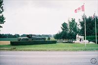 | | | | |
2: Overview
Taken: 19 August 2007
Contributor: T. Larkum
Location Photo ID: 149
Added: 18 September 2009
Views: 207
Has Priority: 0
|
|
|
|
| | | | 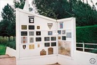 | | | | |
3: Memorial
Taken: 19 August 2007
Contributor: T. Larkum
Location Photo ID: 150
Added: 18 September 2009
Views: 218
Has Priority: 0
|
|
|
|
| | | | 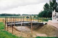 | | | | |
4: Anti-tank ditch and bridge
Taken: 19 August 2007
Contributor: T. Larkum
Location Photo ID: 151
Added: 18 September 2009
Views: 237
Has Priority: 0
|
| | | | | |
|
|